Subsurface Freeze-Thaw Signals at Alaska's Barry Landslide
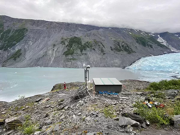
Since 2020, researchers have deployed a network of sensors around the Barry Landslide in Alaska to keep a close watch on ground vibrations. The primary objective is to identify potential precursors to a catastrophic slope failure, which could generate a devastating tsunami in the region. By scrutinizing these seismic records, experts have isolated a specific, previously undefined signal pattern.
These distinctive events manifest as sharp, high-frequency pulses. Data indicates a seasonal rhythm to the activity: the pulses increase in frequency starting in late summer, persist through the winter months, and abruptly cease as spring arrives.
The Role of Subsurface Freezing
Gabrielle Davy and a team from the University of Alaska Fairbanks suggest that these acoustic anomalies stem from the expansion and contraction of water within the bedrock. specifically beneath the neighboring Cascade Glacier. According to their findings, the signals are generated by water freezing and thawing within microscopic fissures in the rock.
While the research team clarifies that these specific pulses do not indicate that the landslide mass itself is shifting, the data offers critical clues regarding the area's hydrology. Understanding how groundwater pressure fluctuates behind the slope is vital, as these internal changes can be a catalyst for eventual slope failure.
Understanding the Hazard at Barry Arm
The urgency behind this monitoring effort is driven by the precarious nature of the Barry Landslide. The site is characterized by steep terrain and weak, fractured bedrock that has lost significant structural support due to the rapid retreat of the Barry Glacier over the past century.
The scale of the potential danger is significant. The unstable landmass is estimated to be roughly 500 million cubic meters in volume and has been slowly creeping for decades. A sudden collapse would send this material plunging into the fjord, displacing enough water to create massive tsunami waves. This scenario poses a direct threat to:
Commercial and recreational vessels, including cruise ships and kayakers.
Coastal communities, such as the town of Whittier.
Ecological stability within the fjord.
Manual Analysis of Seismic Data
To better understand these risks, the area has been heavily instrumented. The recent study represents one of the first comprehensive deep dives into the massive amount of data collected. Rather than relying solely on automated systems, the team conducted a manual review of a full year's worth of continuous waveform recordings.
This hands-on methodology was essential for filtering through the noise. By visually inspecting the data, researchers were able to categorize the various vibrations occurring in the environment. The seismic background noise included:
Tremors from minor earthquakes.
Movement from local glaciers.
Deformation of the slope.
Environmental interference.
By establishing a clear baseline of "normal" background activity, the team could train their eyes—and eventually computer algorithms—to spot irregularities that might signal danger.
Seasonal Correlations and Future Warnings
By cross-referencing the seismic pulses with meteorological data, including rainfall and temperature, as well as ground-based radar, the team confirmed the connection to seasonal changes. The timing and brittle nature of the signals strongly imply they are the result of freeze-thaw processes fracturing the rock. This mirrors findings from similar geological studies in Norway, where unstable slopes exhibited comparable acoustic signatures linked to frost cracking.
Moving forward, these insights are being integrated into broader safety protocols. The Alaska Earthquake Center is currently beta-testing a regional detection system at the site designed to alert authorities immediately if a slope failure occurs. As the science of landslide seismology advances, experts believe that recognizing precursor events will become a cornerstone of early warning systems, not just at Barry Arm, but across similar high-risk locations in southern Alaska.